This past weekend was my first proper trip out of Johannesburg since I arrived here. About time, right? I was getting stir-crazy in the city, so we headed south. Before I came, I knew I wanted to get to either Swaziland or Lesotho. I was told Swaziland is closer, so I started to look into that, but it turns out there really isn't a lot to
do in Swaziland (for tourists). I decided to sort of scrap the whole idea of leaving the country and set my sights on the Drakensberg Mountains instead, which run from the Free State province of South Africa into KwaZulu-Natal and is a UNESCO World Heritage site. As I started looking for accommodation in the Drakensberg, I realized that a number of the lodges to day trips into Lesotho... so I looked at a map and, lo and behold, the Drakensberg abut the eastern border of Lesotho.

Lesotho is completely surrounded by South Africa on all sides (as you can see from the handy-dandy map I stole from the internet). Swaziland is that other circle up and to the right, and it sits between South Africa and Mozambique. The eastern swathe of South Africa is essentially Zulu territory, and in the 1800s, King Shaka of the Zulu ranged around the area attempting to subjugate everyone around -- and largely succeeding. He innovated warfare by introducing a special type of stabbing spear and shield and trained his men to be the best warriors around. They went around knocking on other kingdoms' doors and basically said, "Submit to us or die." Most of the time, people submitted, but sometimes they fled. A huge amount of movement took place around this time as Shaka and the Zulus displaced people all over the region -- the movement is known as the
Mfecane or the
Difaqane (in isiZulu or seSotho, respectively), which means "scattering" or "crushing." This is all stuff that I remember from my South African history class at Berkeley... check out my knowledge!
Anyway, Moshoeshoe gathered together a group of the tribes living in the mountain region that is present-day Lesotho, and built a fort at the top. When Shaka showed up, Moshoeshoe dropped rocks and boulders on his head until he went away, basically. But the mountains weren't friendly, and the Dutch settlers in South Africa discovered diamonds in the region and came in and started trouble. So Moshoeshoe went to the British in Cape Town and bargained for protection. The British came in, kicked out the Dutch, and established Lesotho as a protectorate of the British empire until independence in 1966. So technically speaking, Lesotho was never a colony. Technically.
Anyway. That's your history lesson for the day. Now, to the trip!
Five of us went on the trip. Melissa and I planned the trip (I was the creative force behind it, and then Melissa took over and did all the wonderful planning to make it all actually happen). Then we recruited Jesse, Keith and Kyle to come with us. Melissa and I went to pick up the rental car from Avis -- our sorry little wreck of a car that we drive around in Johannesburg wasn't capable of making the drive -- and then collected everyone around the city. We left the city around 6:30 and drove down to Kestell, in the Free State, as our first stop. We stayed at a lodge called Karma, which was really just a woman's house in a quiet little Afrikaner town. We got there around 10, having stopped at a highway plaza to eat dinner at Wimpy (a classic South African burger chain) for dinner. I had never been to the Free State before, so -- check that province off the list. I was trying to think of which provinces I hadn't been to in South Africa. There are nine, and I've now been to seven of them.

I still need to make it to the Northern Cape and Limpopo. Anyway, that map should also give you a scale of how far we drove: we started in Johannesburg (in Gauteng, the rosy province) and drove south into the Free State until we were just east of the top of Lesotho. So the first day, we drove all the way down through Free State.
It was completely pitch black when we were driving, so we had no idea what we were driving through. The next morning, though, we woke up and realized that the area is
gorgeous. Karma Lodge in Kestell was a lovely place to stay. The woman who runs the place makes jam and competes with it, and has won some "best of South Africa" awards, so breakfast was all the jam and toast and coffee and tea we wanted. Some of the jam was to dieeeee for.


We got up early, loaded up the car and headed into town to pick up Zee, our tour guide for the day trip into Lesotho. I was a bit worried that we were in for a very hokey "cultural experience," where we were going to gawk at people and have very artificial experiences. I needn't have worried. Zee is a South African Zulu, but she lived in Lesotho for a while and really loves the area we went into -- as she told us about the culture and practices, she kept slipping into saying things like "we think" and "our elders," etc. But I'm getting ahead of myself. When we found her, we realized there was a Belgian family with two young girls who were also coming on the tour with us. I had been looking forward to it being just us, but they ended up being pretty unobtrusive (except for their sort of obnoxious photo-taking of
people without asking permission like they were in a museum).
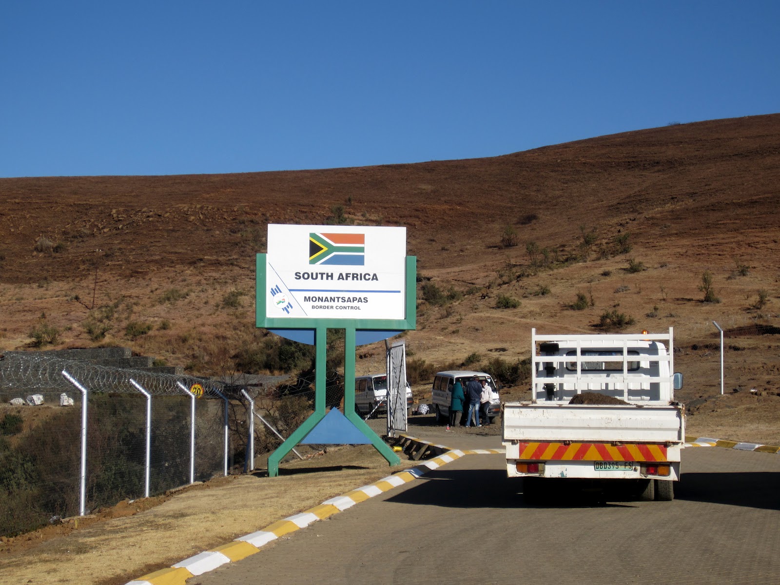
We drove to the border crossing, which was up in the mountains on an untarred road covered in rocks and stones. It's the smallest border crossing I've ever seen -- just two windows for passport processing, and no one was even sitting in them when we arrived. We left our car at the border post, got our exit stamps out of South Africa, and loaded into a minibus taxi to take us into Lesotho.
We drove down through the "no-man's land" section, between the border crossing where you exit South Africa and .... well, where there would
normally be another border crossing to officially enter into the next country. But after we had been driving for about 30 minutes, I asked Zee why it was taking so long (it's usually only about a 5 minute drive), and she said, "Oh, we crossed into Lesotho at that river back there. They don't have a border office -- the Basotho are very welcoming." Er, okay. So I don't have a passport stamp for Lesotho, because the border crossing is I guess so minor and insubstantial that it's just not worth the bother? I can't even imagine that kind of lax security, but on the other hand.... it's not like anyone can really
go anywhere. If someone enters Lesotho and keeps walking far enough, they'll end up in South Africa again. So, that was weird. But Lesotho still 100% counts in my passport stamp competition with my father, despite the absence of the passport stamp. So there.

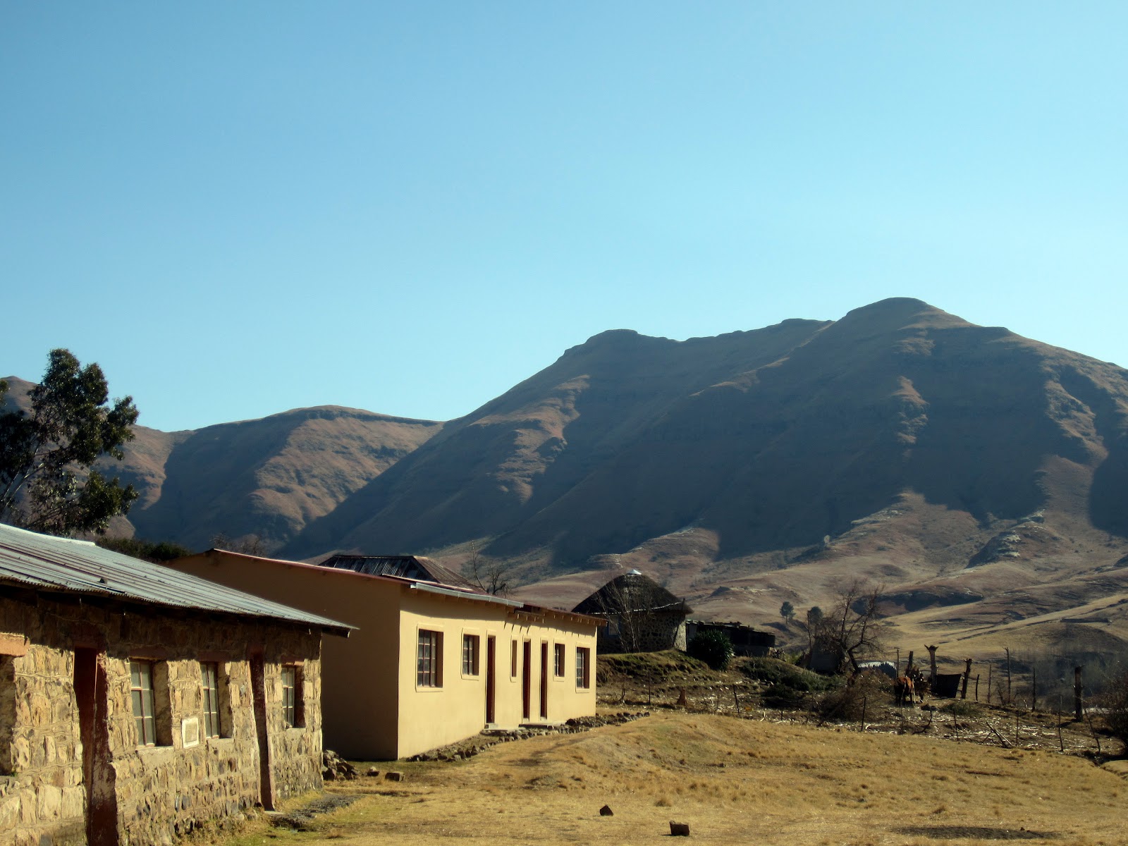
We arrived at the village, which based on some after-the-fact Google searching I think was in the Butha-Buthe district of Lesotho. The village is called Mafika Lisiu, which means "Silo of Stones."
We all piled out the minibus taxi in front of what was obviously a school. Immediately, kids started running over. Obviously they know what's up -- a number of them stuck around for the rest of the day and wheedled chocolate and empty water bottles and other things out of us. I think Zee may have even given them a few coins at the end of the tour. So, a little exploitative, but there it is. Kind of par for the course. Zee told us about the school and how the king in Lesotho owns all the land in the country and has to give you permission to use the land for anything (including building a school), and how the community had to convince him to give them the land to build the school. There was a little curio shop inside that we were encouraged to buy something from to support the school, and at that point I was feeling pretty anxious about whether this was going to be one of those tours and refused to buy anything on principle. I thought about just giving a cash donation, but didn't end up having the chance. The scenery was beautiful, and the kids were hanging around mugging for the camera, so I entertained myself that way instead.

After the school, we set off around the village. Zee kept stopping to talk to everyone, because as it turns out, she knows
everyone. We collected a small herd of children, most of whom seemed to pick a "favorite" tourist and grab onto our hands and try to have conversations in limited English. We ultimately ended up in a little nook overlooking the valley that part of the village sits in, and Zee talked us through the history of Lesotho and a lot of details about culture in the village (courtship and marriage, religion, etc.).
We walked on a bit further, and then sat down for lunch, which was cheese and tomato sandwiches and oranges. Then Zee gave us directions to get up to a higher point near where we were for full panorama views, and we all headed up there. The two kids who were still with us came too.
 |
| We tried a "jumper" shot with one of the kids. Melissa is obviously great at jumpers. We already knew that I was really bad at them. |
When we came down from the top of this spot, Zee took us to see a piece of San rock art. The rock art in the area hasn't been preserved or studied in the same methodical way that it has been in South Africa, so there wasn't a ton of information about it (including how old it was). She told us it depicted a warning that pastoralists were nearby (in other words, the Zulu in what's now South Africa), who claimed ownership over the eland.


We headed back into the village. The plan was to find a rondavel that was offering local beer so that we could try it. There's no cell phone reception in the village, and no electricity I think (although there was a generator at the bar we went to later, but homesteads are pretty far-flung. Zee said that people often just shout to each other when they need to communicate, or send messages with kids. But another way to communicate to the village at large is with flags outside your rondavel. There are different colors you can fly, and each one symbolizes something different -- red might mean that you've slaughtered an animal and are willing to barter meat for an equivalent value of crops, for example, and green could mean that you have an excess of crops and need to give some away before it rots. I forget exactly what color means what, but those were definitely two messages. The one we were looking for was a white flag: a sign that the family in the rondavel has brewed beer, and there is an open invitation for anyone who wants to come and drink some. We had seen a white flag up earlier, but it was gone by the time we got back down. Zee found another one though (apparently it's pretty common on the weekends), so we headed over to that family's hut.

I got distracted though. The group of kids who had disappeared showed up again, and they suddenly all wanted their photos taken. Well, I'm never one to deny small African children anything, so I started snapping away. Then they wanted to
use my camera to take the pictures, so my camera got handed around the circle and the kids took pictures of random things (mostly of me and each other, and also my knees). But at some point, one of them asked me for sweets. Now, I
knew better. I did, I know what happens when there's a group of African kids and you bust out candy, but I was feeling obliging, and I had a chocolate bar in my bag, so I pulled it out and started to break it up. All of a sudden I had 10 little sets of hands grabbing at me. I tried to put one piece in each set of hands, but of course they didn't just take a piece and then go away, and I started to lose track of who I had given to already. I made the fatal error of giving the same kid two pieces and everyone got very upset, so I just shoved the rest into one girl's hands, told her she had to share, and fled into the rondavel where everyone else had disappeared to. Sigh. I never learn.
 |
| Apparently, this is what the world looks like to children. |
Inside the rondavel, everyone was sitting around drinking the local beer. It's brewed from maize and sorghum, which is yeast-like and naturally ferments. It didn't taste like beer at all. Zee had described it as kind of yogurt-y, and that was pretty accurate. Compared to some other local beers I've tried, it was eminently palatable. And there was a ton of it, so we all sat around for a while drinking and sort of talking to the family in the rondavel. The young woman there spoke English pretty well, but no one else did that I noticed.
After we left their home (and Zee told them the beer was "on the house," so we left to loud cheering), we went to another woman's house, although we didn't meet her or go inside. But she had prepared a plate of traditional Lesotho spinach and pap for us. Pap is basically white kernel maize, pounded and mixed with water, and you use it to scoop up whatever food you're eating. The spinach was possibly the most amazing thing I've ever eaten, ever. Lesotho spinach is different from other spinach somehow, although I didn't see how except for its exceptional deliciousness. It was coated in butter and other unidentifiable and delectable things, and we cleaned the plate without a problem.
At that point, we were pretty much done. We headed to the pub of the village, called Two Sisters, which was hooked up to a generator and had a little all-purpose store attached, which sold warm beer and sodas. We got beverages and went into the bar, where there was a pool table and a group of bored-looking Basotho. One of the local guys agreed to play some of the guys in our group in pool. according to local rules. I don't really know the actual rules of pool, so it was all a bit over my head, but it was something like if on your turn you don't "cushion" the ball (hit it on the sides?), then your opponent gets to go twice on his next turn. Keith and Kyle both took turns, and they both lost. The Mosotho was really good at pool.


Our minibus taxi ride showed up, so we got back in and went back to South Africa. Then we drove another 2-3 hours south into the Central Drakensberg to Inkosana Lodge in the Champagne Valley, so as to be better situated for hiking the next day. There was a particularly lovely 20 km stretch of road where the government just... gave up making the road on one side. I kid you not, there's a sign saying the road is closed, and one entire side of the road is just unpaved and covered with giant rocks at intervals to make it impossible to drive on. So both sides of traffic have to drive in one lane, which means you have to pull over when a car is heading towards you. Oh, also, there are sections of the road that are more pothole than road. For 20 kilometers. It slowed us down considerably, and I was relieved when I got back to driving on proper tar roads, even if the potholes didn't go away entirely. That slowed down our progress, but we made it to Inkosana on Saturday night and crashed out a bit.
I'll post about our second day (which will be a much shorter entry) separately and later, as I think this is quite enough for now.